Google Earth

Colorado Cowboy

Super Moderator
Jun 8, 2011
8,338
4,722
83
Dolores, Colorado
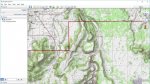
Don't know how many of you use Google earth for research, but some of my general observations.

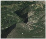
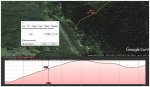
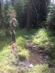
I do use it, but only for an overview of the country. I just got back from a scouting trip to a unit here in SW Colorado that I have never hunted or even been in before. I looked at Google Earth images and had some general impressions of the terrain and cover. I was surprised at how different it looked when I was actually there. From the images the country looked pretty open with lots of areas of no vegetation....not! The GE images were taken on April 14 and there was still a little snow in the shady north facing areas...not much, just a shading of white. When I was there this week, all the oak brush and aspens were leafed out and what looked like open cover, was really dense brush.

A total different perspective. Look at the date the image was take when you are on Google Earth and take that into consideration. Just sayin..............
 
Last edited:

JimP

Administrator
Mar 28, 2016
7,312
8,694
72
Gypsum, Co
You can change the date of the image on GE by going up to their toolbar and look for the clock face. Click on it and a slider bar will show up that you can move backwards to a time frame similar to what you are in now.

I just use GE as a reference anymore.
 

Hilltop

Veteran member
Feb 25, 2014
3,846
2,230
Eastern Nebraska
You can change the date of the image on GE by going up to their toolbar and look for the clock face. Click on it and a slider bar will show up that you can move backwards to a time frame similar to what you are in now.

I just use GE as a reference anymore.
Had no idea that was available- thanks for the tip.
 

wa-hunter

Active Member
Apr 24, 2014
235
7
You can change the date of the image on GE by going up to their toolbar and look for the clock face. Click on it and a slider bar will show up that you can move backwards to a time frame similar to what you are in now.

I just use GE as a reference anymore.
awesome tip had no idea you could do that!! thanks!
 

Gr8bawana

Veteran member
Aug 14, 2014
2,671
605
Nevada
I have looked at an area we hunt regularly on Google Earth and what you see on it is far different from what is real life. Google Earth makes the area look very flat and we know just how steep it really is. The vegetation also looks very thin when in fact it is not, the same thing you found.
Google Earth is only good to get a general lay of the land, roads in the area and maybe larger water sources.
 

hoshour

Veteran member
Had no idea that was available- thanks for the tip.
I've used that historical image slider quite a bit but there are usually not many different seasons to choose from. You may have to go back several years to get the season you want. The slider will only stop on dates that have images.

Make sure that under View you have Toolbox checked and then play with those things like the Ruler to measure distances, Add Placemarks and use the Sun icon to change the time of day and angle of the sun.

I assume everyone knows that holding down the shift key while you scroll your mouse changes the tilt of the landscape so you can see elevation better and holding down the CTRL key while you scroll rotates your view.

You can usually find GE layers under GIS downloads on the Fish and Game website.GE layers end with kml or kmz. The F&G will be for things like unit boundaries and may have migration routes, winter or summer ranges and concentration areas. The web has all sorts of other layers. For example, see http://cpw.state.co.us/learn/Pages/KMZ-Maps.aspx

Download them to your desktop and when you click on it, it will automatically open GE. They will show in Places in the Sidebar and you can save them if you like.

On the CO link I gave, if you download the one for mule deer, when you click on the downloaded file and GE opens, unpack the layers by clicking on the + signs and then take the check out of each layer's box and then go back and check just the ones you want to see.

You'll probably have to adjust the opacity (transparency) and may want to change colors or line widths. Do that on any layer by right-clicking on it in the Sidebar and choosing Properties, then Style/Color, then Share Style. Often you can change the properties for an individual area like a unit by right-clicking on it on your screen. For instance, you may want to have just the boundary line in say red 3.0 line width and not have a fill color so you can see details better.

You can also print or make a pdf at various resolutions up to 4k there just under the toolbar. It doesn't change the resolution on your screen as you view it.

Be aware too that there is Google Earth Pro on your desktop which has far better clarity but is very slow to load, especially if you add kmz or kml layers, and the Google Earth browser version. The browser version is much faster to load and in some ways easier to do things like 360 degree fly arounds, but if you zoom in you'll see that the brush and trees don't look anything like the actual. The lack of detail is why it is so fast.

Or, you can skip all this complexity and use onXmaps. The new subscription service that is $100/year and includes every state is awesome.
 
Last edited:

rammont

Active Member
Oct 31, 2016
228
4
Montana
Google Earth makes the area look very flat and we know just how steep it really is.
Actually, you can produce a 3D effect with Terrain layer enabled.

Go to the top menu bar and select View.
Select Sidebar.
The Sidebar will show Search, Places, and Layers.
Select Layers.
Layers will expand, toward the bottom you should see Terrain - select it and the map will have shadows and relief that will help you see elevations and such. If you zoom in and move your camera elevation you can create a better match to what you'll see when you are on site.
random mountain image from GoogleEarth with relief.jpg

Also, if you want to get a better idea of the elevation and such
Go to the top menu bar and select Tools
When Tools expands select Ruler
Select Path
In the Path window select the units (feet, miles, etc.) and click on the Show elevation profile box.
Now draw a line along the surface that you want to see the elevation and slope of. There will be a window on the bottom of the screen that will show how the elevation rises along the line that you draw. If you point your curser anywhere along the graph at the bottom of the page you will see slope and elevation information at any point along that line.
random mountain image from GoogleEarth with relief and path.jpg
 
Last edited:

hoshour

Veteran member
Actually, you can produce a 3D effect with Terrain layer enabled.

Go to the top menu bar and select View.
Select Sidebar.
The Sidebar will show Search, Places, and Layers.
Select Layers.
Layers will expand, toward the bottom you should see Terrain - select it and the map will have shadows and relief that will help you see elevations and such. If you zoom in and move your camera elevation you can create a better match to what you'll see when you are on site.
Under More on the Sidebar you will find things to check for National Forests like campgrounds, facilities, trailheads and lookouts. You can also check off gas stations and lots, lots more.
 

Umpqua Hunter

Veteran member
May 26, 2011
3,576
88
61
North Umpqua, Oregon
You can change the date of the image on GE by going up to their toolbar and look for the clock face. Click on it and a slider bar will show up that you can move backwards to a time frame similar to what you are in now.

I just use GE as a reference anymore.

The historical images is really helpful. One way I use it here in Western Oregon is to look for clearcuts and where the "reprod" (newly planted Douglas firs) are just the right age. I often toggle back and forth between two different years and your eye will pick up the area where there were trees one year, then a clear cut another and you can use that to age the clearcuts. At the right age, those clearcuts are prime with good feed and cover without being overgrown.

I have also done a similar technique when looking for burns.

Last year I used if for my son's Oregon antelope hunt. I was looking for the most reliable water holes. I scanned back until I found the year with the most dry water holes, then looked for ones with water that year.

Also certain details will be easier to see in one year's image versus another year's image.

It's a really great tool.
 
Last edited:

WapitiBob

Veteran member
Mar 1, 2011
1,385
58
Bend, Orygun
GE Pro is currently the best Internet Scouting tool available although I see some light at the end of the OnX tunnel.

Soon to be wallow found from 2 miles up
wallow.jpg

TOPO
topo.jpg

Forest Visitor maps
forest.jpg

GeoPdf's
geopdf.jpg

TopoFusion is the best app I've found for offline topo and sat imagery, ability to transfer those maps to GPS, and GPS point/track bidirectional transfer.
 

jroplanner

Member
Jun 12, 2014
70
0
California
Great thread. Google Earth has it's limits, for sure. The aerial images used are not current. They may be fairly recent, but I wouldn't recommend using the image as an indicator of on-the-ground conditions. The topographic relief is not perfect either, it won't give you a real indication of the nuance of the details of the site specific topography. However, it is a great tool to use in combination with other sources of mapping, and is especially helpful in navigation and where to find roads and access planning.

One helpful hint, many agencies publish Google Earth layers containing very helpful information. These are called "KMZ" files. I've contacted the Colorado DFW and obtained deer and elk management layers for Google Earth that show migration routes, concentration areas for summer and winter, resident population locations, highway crossings, etc. These are based on GIS data from in-field research. I highly recommend contacting your stat DFW/DFG offices where you plan to hunt and ask if these KMZ files are available.
 

RICMIC

Veteran member
Feb 21, 2012
2,014
1,793
Two Harbors, Minnesota
You guys lost me right after, "You can try this." I have my feet firmly planted in the early part of the 20th century, and occasionally just have to pull the blankie over my head to feel safe. I have my NFS map, some MYTOPO, GPS with ONYX chip, a box of bullets, a full tank of gas, its night and I'm wearing sunglasses. HIT IT!!!
 

rammont

Active Member
Oct 31, 2016
228
4
Montana
Learning how to use your tools is a matter of motivation and interest, not age. I'm 60 years old and I'm always looking for better ways to go hiking and hunting.