
I use it a lot myself to look and features I’ve found on passed hunts or for looking for springs, to scout.
Google Earth
- Thread starter Ikeepitcold
- Start date
mallardsx2
Veteran member
- Jul 8, 2015
- 4,035
- 3,414
I use it religiously.
I create waypoints and put them in my GPS all the time.
I use it for work a ton also. Estimating jobs and planning routes / flights. I find its elevations to be reasonably accurate as well.
Admittedly, I am on google earth at a minimum of 2 hours a day and have been since it was released. I have saved myself a lot of hassle and a lot of walking by using google earth.
hoshour
Veteran member
I think the original question is who relies on GE to scout and then goes straight to what they liked on there without any boots on the ground scouting.
I always get to the unit a couple days early because things just look different when you get there, plus you need to see the current condition of roads and trails and foliage and look for sign. I've gotten to a unit and found the road I wanted to use washed out or blocked, seen a bunch of trucks and trailers where I had in mind to camp or hunt, glassing spots actually turn out to be blocked with trees, and so on.
Maybe some guys are super-pressed for time, especially since this question almost assumes they travel a long ways both directions, but I'd rather lop off a couple days from the end of the hunt than not have any time to get set up and familiar with things in person before the shooting starts.
WapitiBob
Veteran member
I've gone straight from GE to my initial hunting spots in every out state hunt I've done, then maybe branch out as the hunt progresses.
I have looked at a lot of new areas in the past. However, if I haven't scouted it I will generally go to a place that I have found big bucks on previous hunts.
kamptown
New Member
- Nov 19, 2016
- 16
- 0
So in an effort to branch out to some new areas since we moved to Idaho from Reno I have used GE to...?break the ice?? I guess. We have hunted farther north the past couple years, and I spent hours ?scouting? on GE. I can say it is only a tool, as good or bad as the effort put into it. I also contacted some local knowledge concerning roads, access, and many other pertinent factors. I have been looking in to a contour line overlay for GE as well, to help with the lack of altitude reference. I have used this for dirt bike rides before and have earned a nasty reputation for miserably hard rides, eg; the trail of tears, crybaby canyon, you get the gist.
Sent from my iPhone using Tapatalk
Sent from my iPhone using Tapatalk
WapitiBob
Veteran member
add a topo map server; click the "view on ge" button, then save the file to your pc, then open in GE.
http://www.earthpoint.us/TopoMap.aspx
http://www.earthpoint.us/TopoMap.aspx
blacktailhunter
New Member
I use it sometimes, but use mytopo.com more often because you can switch between a road map, topographic map, and satellite imagery.
BAKPAKR
Active Member
- May 10, 2018
- 194
- 121
I live in West Virginia and I have lucked in to various tags over the years. While having feet on the ground is certainly the best way to scout, I simply don’t have the time (and probably not the money) to make a separate pre-season scouting trip very far from home. So, I rely on GoogleEarth to give me an idea of what an area looks like and to find places to focus on when I get there. That has worked for me on moose in Idaho, New Hampshire, and Maine. I didn’t actually shoot a New Hampshire moose as I let my father, who was my sub-permittee, shoot the bull.
GOSHENGRUNTER
Active Member
I've used Google Earth for scouting on quite a few hunts without doing any boots on the ground scouting. I've had pretty decent success so far. I find that its pretty common for an area to look totally different in person though.
I will add that GE isn't the only mapping tool available. A great and overlooked source is BING maps. They use different satellites than GE and pretty much always have a different view. sometimes its a lot closer and more clear.
I will add that GE isn't the only mapping tool available. A great and overlooked source is BING maps. They use different satellites than GE and pretty much always have a different view. sometimes its a lot closer and more clear.
GOSHENGRUNTER
Active Member
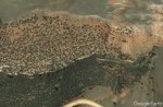
here's an example. Although this particular spot (where I killed my 2017 Mule Deer) doesn't show much change, you can tell the difference in image. Its a nice tool to compare.I've used Google Earth for scouting on quite a few hunts without doing any boots on the ground scouting. I've had pretty decent success so far. I find that its pretty common for an area to look totally different in person though.
I will add that GE isn't the only mapping tool available. A great and overlooked source is BING maps. They use different satellites than GE and pretty much always have a different view. sometimes its a lot closer and more clear.
This spot is one I located and identified from GE scouting as an area I thought guys would drive past and never drop off to glass. We killed 2 bucks in this drainage and were within 100 yards of the road for both shots. you can't see this at all from the road. It's not a tough spot to get to, but its an easy on to over look

Fink
Veteran member
Update - Make that 12 gobblers on ground I've never set foot on, scouted only via google earth. I love Google Earth.I'm pretty much addicted to google earth at this point, and probably spend a few hours a week on it, scouting areas. I use it to find access into areas that have limited access, and to avoid areas that have easy road or trail access.
I use it quite a bit here at home, for turkeys and waterfowl. Historical images are really nice for being able to see how much water it takes to flood certain areas, when and where sandbars on rivers get exposed, etc..
In the last 5 years, I've probably killed no less than 10 spring gobblers on ground I've never set foot on, only scouted from google earth