Where do I find high-quality WY unit maps? Or text descriptions of the units?

Kyle Bradshaw

New Member
Mar 13, 2014
4
0
Albion, Idaho, United States
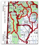
I'll be hunting in WY for my first time and I can't find any high quality maps that show the exact boundaries. The only PDF map on the F&G site isn't very detailed. Specifically, I'm trying to determine the northern border between Region G & Region H (144 & 153/142/151). Idaho uses maps & text descriptions for each unit...I'm hoping someone can point me in the right direction! Thanks!

deerWY.jpg
 

hoshour

Veteran member
You can download free map PDFs or buy maps from the USGS. To download them as a PDF that you can use on your desktop, laptop, tablet or phone go to http://store.usgs.gov/b2c_usgs/usgs/maplocator/(xcm=r3standardpitrex_prd&layout=6_1_61_48&uiarea=2&ctype=areaDetails&carea=%24ROOT)/.do

In the search box, type in WY and then zoom in until you can see the names of the areas. Type in a name of an area and when it comes up, click on the red balloon and a list of downloadable files will come up.

There is also software that is somewhat complicated to download and set up called TerraGo that will let you see layers. You might want to contact them for help on that but the PDFs as topo maps alone are useful.

I love carrying PDFs of the areas I'm hunting on my tablet and phone.
 

hoshour

Veteran member
You'll have to get the free Terra Go software to see land ownership boundaries. I am not sure that Terra Go shows unit boundaries so this may not be exactly what you're looking for if you want to see a unit boundary line on the map but they are high quality maps to use in conjunction with the descriptions. Plus, its free.

Otherwise, you'll probably want to go to Trimble maps at http://www.gpshuntfish.com/Elite/?gclid=CNHHqcDTkL0CFWuhOgodkScAwg
 

Kyle Bradshaw

New Member
Mar 13, 2014
4
0
Albion, Idaho, United States
What about a good old text description? Example from Idaho:

Unit 11—Those portions of Nez Perce, Lewis, and Idaho
counties within the following boundary: beginning at the
mouth of the Clearwater River, upstream to U.S. 95 bridge near
Spalding, then southeast on U.S. 95 to the Graves Creek Road
at Cottonwood, then south on Graves Creek Road to the Salmon
River, then downstream to the Snake River, then downstream to
the mouth of the Clearwater River, the point of beginning.

How can the WY F&G expect me to look at a fuzzy PDF and know where I can and cannot hunt?
 

libidilatimmy

Veteran member
Oct 22, 2013
1,140
3
Wyoming
The Wyoming GF does give the legal (text) description of the areas in the hunting regulations. You can pull up last years regulations on the web site I believe.
 

Musket Man

Veteran member
Jul 20, 2011
6,457
0
colfax, wa
I would get a map form mytopo since they show unit boundaries, or FS/BLM maps for the area and a good gps and huntinggpsmaps chip to know where the boundaries are when you are hunting.
 

LaHunter

Active Member
Aug 24, 2012
322
0
N.E. LA
The WY G&F website has the description of the units somewhere. I have printed them for the unit that I hunt.
For maps, mytopo has great maps. The have pre made maps for the different units showing boundaries, or you can customize the map how you want it and they can print them on tear resistant and water proof paper. You can even get satellite image maps from them. They aren't cheap but the quality is outstanding.

Good Luck
 

mnhunter

Active Member
Aug 23, 2011
226
0
Andover, Minnesota
They are very good but sometimes cost alot more then BLM/FS maps but sometimes a unit is on several BLM/FS maps and mytopo is cheaper. Kinda depends on the area.
No doubt, If I am hunting NF, I just go with the USGS maps downloaded off their website and print them out on a plotter at kinko's.

The other technique I use alot is if I know a specific area I am going to be hunting. I will crop down a USGS map and a national forest map using powerpoint, add any notes I want, print them out on 8.5x11, and laminate them back to back using 3M self sealing lamination pouches. They end up being water proof, and will fold up and go in a hip pocket. I am happy to email an example and show you what they look like.

http://www.amazon.com/Scotch%C2%AE-Self-Laminating-Sheets-Letter-LS854-25G/dp/B00006HZ5F/ref=sr_1_13?ie=UTF8&qid=1394814396&sr=8-13&keywords=3m+laminating+pouches
 

nunt'nbutmuleys

Active Member
Feb 25, 2011
195
0
DIY Hunting Maps and MY TOPO are both excellent choices. Just picked me up a Garmin GPS and plan on getting the Hunting maps for it, heard really good things about this method especially when trying to decide if the land is private or public. Cant wait to give it a try.