What am I looking at?

MOhunter28

Member
Dec 30, 2015
56
0
Branson, Missouri
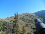
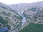
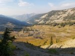
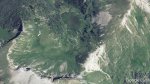
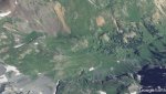
I think I have narrowed down my choices for a high country mule deer hunt (archery). I really struggle with the E-scouting via Google Earth. I look at the aerial and I think it looks good but let's be honest with my limited time in the high country I have no idea really what is good vs not good. So I took 3 screen shots that I thought may be good. #1 is an area very open with what I think are willows spread throughout the basin. #2 is a mix of conifer trees on some slopes and in the valley but also has a large open area. #3 is what I tend to look for, very few trees and steeper slopes. Hopefully these uploaded in proper order.

For all I know these could be terrible places. Feel free to comment the good and bad, it would be awesome if you could even upload a pic of a "typical" mule deer basin. I'm sure I'm going to get an answer "they are where you find them" but as far as E-scouting goes what do I look for on Google Earth?


Basin 1.jpgBasin 2.jpgBasin 3.jpg
 

go_deep

Veteran member
Nov 30, 2014
2,650
1,984
Wyoming
They all look good to me, from the limited amount I can see. Not knowing if you moved the screen to know which way North is for sure Or see the area in a topomap form to see terrain features is hard to know for sure, but yea at a glance looks like it would be.

This is how I found almost all the areas I hunt, just by scanning Google Earth, then call the local G&F. Worked out alright for me.
 

tttoadman

Very Active Member
Nov 16, 2012
629
1
Oregon
I think pic 1 is more elky than mule deer.

I really like pics 2 and 3. pic 3 has the large rocky bench on the right with scattered trees. That is where I would be keying in for that area. It is also broken up enough that a guy could attempt a stalk. The rest of the basin may be tough with such smooth features.
 

Gr8bawana

Veteran member
Aug 14, 2014
2,670
602
Nevada
I think pic 1 is more elky than mule deer.

I really like pics 2 and 3. pic 3 has the large rocky bench on the right with scattered trees. That is where I would be keying in for that area. It is also broken up enough that a guy could attempt a stalk. The rest of the basin may be tough with such smooth features.
Scouting through Google Earth I guess is better than no scouting at all.
It is very difficult to get an idea of what the terrain is really like.
One of the areas we have been hunting in NV for over 30 years looks quite flat and open when in fact it is anything but.
Also in pic #1 what you think are willows are really groves of aspen trees that could be 20 feet tall.
 

MOhunter28

Member
Dec 30, 2015
56
0
Branson, Missouri
Ya its so hard to determine. Last year on our high country hunt the deer keyed in on those patches of trees in the base of the basin and would move up onto the open slopes to feed. I've just never had the experience in more "bare" treeless basins to determine if it worth while to fine deer there.
 

Gr8bawana

Veteran member
Aug 14, 2014
2,670
602
Nevada
These 2 pics are from a scouting/camping trip in central NV this past year. When it got light and before the sun came up the bucks were up feeding on the highest slopes between 9,000 and 11,000 feet. When when the sun came out they simply melted into the highest patches of trees. The lower areas of trees is where the does and fawns and little bucks were hanging out.
Google Earth also makes this area look quite flat and open.
DSCN0507.jpgDSCN0505.jpg
 

ivorytip

Veteran member
Mar 24, 2012
3,768
50
44
SE Idaho
some of the biggest bucks I've seen have been bedded in the thick elky timber ridges, usually on the top quarter. don't overlook the lowland flats either. you know, that places that never get glassed.
 

go_deep

Veteran member
Nov 30, 2014
2,650
1,984
Wyoming
That's were doing stare and compare against Google maps with the terrain feature turned on is good. Lets you see shelves, benches, ravines, saddles, razor backs, any elevation changes in general.
 

tdub24

Veteran member
Dec 15, 2011
1,331
558
Carlin, NV
Before my 1st elk trip in 2008 I spent hours and hours overlooking the unit via Google Earth. Once I got the the unit, I recognized everything that I have scouted.....almost like I have been there before.

OP, all 3 pictures will hold deer, picture one is better elk country though.
 

MOhunter28

Member
Dec 30, 2015
56
0
Branson, Missouri
These 2 pics are from a scouting/camping trip in central NV this past year. When it got light and before the sun came up the bucks were up feeding on the highest slopes between 9,000 and 11,000 feet. When when the sun came out they simply melted into the highest patches of trees. The lower areas of trees is where the does and fawns and little bucks were hanging out.
Google Earth also makes this area look quite flat and open.
View attachment 18413View attachment 18414
Thank you for sharing those pictures, that's the type stuff I'm trying to find. I get so caught up in the idea that high country=mule deer in the open, but it seems reality is that they only feed in the open and return to the cover of the trees even if it a single tree or what not. I do realize a cliff ban or boulder can serve the same purpose.

I never would have thought pic one was a more suited to elk but I'm not an elk guy....yet
 

MOhunter28

Member
Dec 30, 2015
56
0
Branson, Missouri
Idaho Basin.jpg

In Idaho this is where we found bucks but this was a spot on Google earth I did not have picked out as the "best" basin I want to hunt or look at. I guess with Google Earth looks can be deceiving.