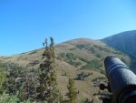
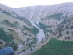
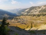
I think I have narrowed down my choices for a high country mule deer hunt (archery). I really struggle with the E-scouting via Google Earth. I look at the aerial and I think it looks good but let's be honest with my limited time in the high country I have no idea really what is good vs not good. So I took 3 screen shots that I thought may be good. #1 is an area very open with what I think are willows spread throughout the basin. #2 is a mix of conifer trees on some slopes and in the valley but also has a large open area. #3 is what I tend to look for, very few trees and steeper slopes. Hopefully these uploaded in proper order.
For all I know these could be terrible places. Feel free to comment the good and bad, it would be awesome if you could even upload a pic of a "typical" mule deer basin. I'm sure I'm going to get an answer "they are where you find them" but as far as E-scouting goes what do I look for on Google Earth?


For all I know these could be terrible places. Feel free to comment the good and bad, it would be awesome if you could even upload a pic of a "typical" mule deer basin. I'm sure I'm going to get an answer "they are where you find them" but as far as E-scouting goes what do I look for on Google Earth?


