Colorado high country mule deer hunt

Work2hunt

Veteran member
Mar 2, 2013
1,366
11
St. Louis, MO
Ok fellow Eastmans Forum members. I can’t wait anymore. I finally pulled the trigger, used all my points, applied for a high country early season rifle mule deer hunt and drew a unit 36 tag. I’m am extremely excited!!!

In an effort to use every bit of time between now and when I leave for the hunt, in early September, to prepare, I come to you you. I am wanting to do this hunt DIY so I began researching these hunts several years ago and heavily scouting this unit over the past few months. I have been looking at every map I can get my hands on (National Geographic Trail maps, Topo maps, Forest Service maps, BLM maps, etc), various sources of aerial photos (GE and Bing Maps mostly), and have spoken with the area Game Warden and Biologist several times. I feel I am starting to understand the area and have broken the area into 4 main parts.

Problem is I am no mule deer expert and all the nooks and crannies of the Gore Range appear to look great. I’m hoping to get out for a long weekend of scouting towards the end of July or beginning of August, but I may not be able to. Back-up plan is I will be arriving at least 5 days before season opener to get some boots on the ground and hopefully familiarize myself with the area before season opener and hopefully identify a few candidates.

If anyone has been to this area I would love to hear from you. Especially, if you have hunted this time of year on an archery, muzzleloader, or early rifle hunt. Even if you haven’t been to this unit, but have hunted similar “above treeline” hunts in other areas I would like to tap into your knowledge, too.

Do you have any pictures or knowledge you can share?

What do you look for on maps or aerial photos that help separate these high country spots out from one and another?

Do you find certain areas are more successful than others that can be identified when “map” scouting?

Obviously, I would think the farther away from people the better. But, one of my “four” areas that I identified has 5 trails that go through it each around 1.5 miles apart and running roughly parallel to each other. Do you think it is worth investigating the mid-points between each trails?

Anything I can look for on maps that I should avoid?

Anything I am missing?
 

Ikeepitcold

Administrator
Staff member
Feb 22, 2011
10,047
1,641
Reno Nv
I don't know the area but it sure sounds like your doing your reseach. Boots on the ground has always been the best help for me. Maps can help but things can sure look a lot different when your there.

Good luck and I'm sure there are some guys here that know the area and will help.
 

JimP

Administrator
Mar 28, 2016
7,327
8,714
72
Gypsum, Co
Congrats on the tag, now is the hard part.....getting into the best shape of your life. While it is a high country hunt there are plenty of trees up there along with large grassy areas for them to feed in. The best thing that you can do is to get up there early and get up on a nob of a hill and start glassing.

One thing that you do need to prepare yourself is to read up on altitude sickness and be prepared for it since you will be around 10,000'+ during your hunt.

There was another hunter that I know of that hunted the area a few years ago and he went in off of the Vail Pass rest area. That gets you up high to start with but it is a rugged hike over the firs set of ridges. Another way in is out of Vail on the east side. If you look at Google earth you will see where a frontage road runs under I-70 to the parking area and trail head.

Good luck on your hunt.
 

hoshour

Veteran member
JimP is right on about getting in great shape. Timberline should be around 11,500, and coming from Missouri, whether you hunt at 10K or 11K, that will really test you.

It's a good idea to get there early and start to acclimate. Your body will start producing more red blood cells and you'll feel a little stronger each day. It's not quite sheep hunting, but running or hiking the steepest hills you can find and doing a lot of stairs with your hunting boots and backpack on will make a lot of difference.

Definitely get there ahead of time and get to know the area. Things just look so much different in person than on Google Earth, usually way steeper and higher.
 

JimP

Administrator
Mar 28, 2016
7,327
8,714
72
Gypsum, Co
It's not quite sheep hunting, but running or hiking the steepest hills you can find and doing a lot of stairs with your hunting boots and backpack on will make a lot of difference.

Definitely get there ahead of time and get to know the area. Things just look so much different in person than on Google Earth, usually way steeper and higher.
There is actually a pretty good size herd of sheep up there as well.
 

graybird

Active Member
Feb 22, 2011
388
119
Colorado
I strongly suggest doing stairs, but coming down. You never think about the stress on your knees and feet with a heavy pack coming downhill until you're in the middle of it. To me, stairs downhill is more important than stairs uphill.

Good luck with your tag! I'm thinking I'll be in a neighboring unit chasing high country mule deer during the MZL season, unless I mysteriously drew my 4th season tag. There are definitely big bucks up high, but you need to get to them first and then off the mountain with one on your back.
 

nebowhunter

Member
Mar 10, 2011
94
0
Northeast Nebraska
I was with a friend that hunted that unit a few years ago. We were able to do a lot of glassing from the south side of the interstate west of the rest stop. He was able to harvest a deer, but not the biggest we had glassed. There was a lot of foot traffic on the weekends from the interstate. I myself will hunt that unit again when I get the points I need.
 

Ridgerunner

Active Member
Feb 21, 2011
308
0
You're doing your homework right, make sure your lungs and legs are in shape will be critical.


Sent from my iPhone using Tapatalk
 

Slugz

Veteran member
Oct 12, 2014
3,665
2,341
55
Casper, Wyoming
http://flattopswildernessguides.com/physical-preparation-for-high-altitude-wilderness-elk-hunts-endurance-and-strength/#!prettyPhoto

On the getting in shape part...above is a link. The moving incline workouts combined with kettlebells worked for me. I don't know the above outfit, just use the web page as I found the info helpful and what worked for me....that combined with trekking poles IMO I think is key to keep you going. Scouting 5 days prior is also gonna work well. I would prioritize that for scheduling purposes.

A comment about the early above treeline stuff.....may or may not help...but what I've seen. I spend a fair amount of time in the Sangre De Christos chasing elk.....most of my glassing is done from rocks above treeline up high mainly due to the elk "drainage jumping" as I call it. Regardless of the trail system below I've noticed two distinct movements of the muleys.....they either traversed at the same altitude in the open or stuck to the edges. That was post the opener of the rifle above treeline season. Post a little pressure they would find that bowl to go hide in....Seemed like those bowls also had a good deal of cover very close and a spring or two.

Lastly I like using this method while prepping for a hunt in a new area. I take he best map I can that covers the entire zone I'm in. I'll highlight every road, trail, access point...etc etc......anything that a human can be on or apply pressure.....more times than not that resulted in a "huh" look at that big hole there. Sometimes we couldn't get "there" due to terrain or access......but more times than not we could....and found them. Good luck!!! Nothing better than Colorado in September
 

Work2hunt

Veteran member
Mar 2, 2013
1,366
11
St. Louis, MO
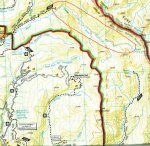
Does anyone know if there is an actual trail between the Booth Lake Trail and the Upper Piney River trail? From the Nat Geo Trails Map those are 2 main trails, but there appears to be a "Private or Unmaintained" trail that extends from the Upper Piney River trail and heads SE towards the Booth Lake Trail.
Capture.jpg

Just wondering if it is a trail or not and if it is actually used. Not sure what the difference between a "trail" and a "Private or Unmaintained" trail is.
 

JimP

Administrator
Mar 28, 2016
7,327
8,714
72
Gypsum, Co
Not that I know of.

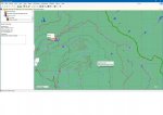
Here is a screen shot of the area from my Onyx maps. It does show a trail below Booth Lake that will go over to the Piney Lake areaEagles Nest.jpg
 

JimP

Administrator
Mar 28, 2016
7,327
8,714
72
Gypsum, Co
That is one problem with maps, you never really know what it is until you actually set foot into the area. I just updated my Onyx maps for Colorado just the other day so it should be right, but no guarantee on that and I don't know of anyone that has been hiking up that direction in years.
 

BKC

Very Active Member
Feb 15, 2012
835
163
The high plains of Colorado
I killed my goat in that area in 1997. Straight up from booth lake is a small saddle that I believe the locals call the grand traverse. It has somewhat of a trail on the booth side but nothing of a trail after that. If you start from the piney river side it may be easier to find a trail. If you hunt deer dont plan on going back and forth too often. It is pretty steep. Just go to the top and glass. I killed my ram a couple of drainages over in 2001. It is good country but I only have seen one deer that I would have burnt a lot of points on. I saw him during sheep scouting and never saw him again. There are a lot of hikers, especially on the booth side. Quick access from I 70 makes it popular. I have 12 points for deer but I am considering other high country units or Gunnison area.