
wind river indian reservation
- Thread starter mainman38
- Start date
libidilatimmy
Veteran member
The rules are confusing here. You are allowed to hunt deeded land within the reservation. There is also an area called the withdrawal area, which is 97 antelope and 157 deer where normal rules apply.
libidilatimmy
Veteran member
Musket Man
Veteran member
I believe the OP is asking about the south eastern part of 83 that is on the reservation. 83 is a unit I have considered before but decided against it because of the reservation land in it.
libidilatimmy
Veteran member
Area 83, by definition, is not on the reservation. However, one would still deal with the access issues that are present in this area.
Musket Man
Veteran member
looking at this map there is a part of 83 that appears to be on the reservation. That part would not be huntable would it?

libidilatimmy
Veteran member
If this map is accurate with the unit boundary, then yes and no, to answer your question. You can still hunt deeded land, with the owners permission mind you, the rest would be unhuntable. Let me review the legal description of the area and I'll chime back in.
Musket Man
Veteran member
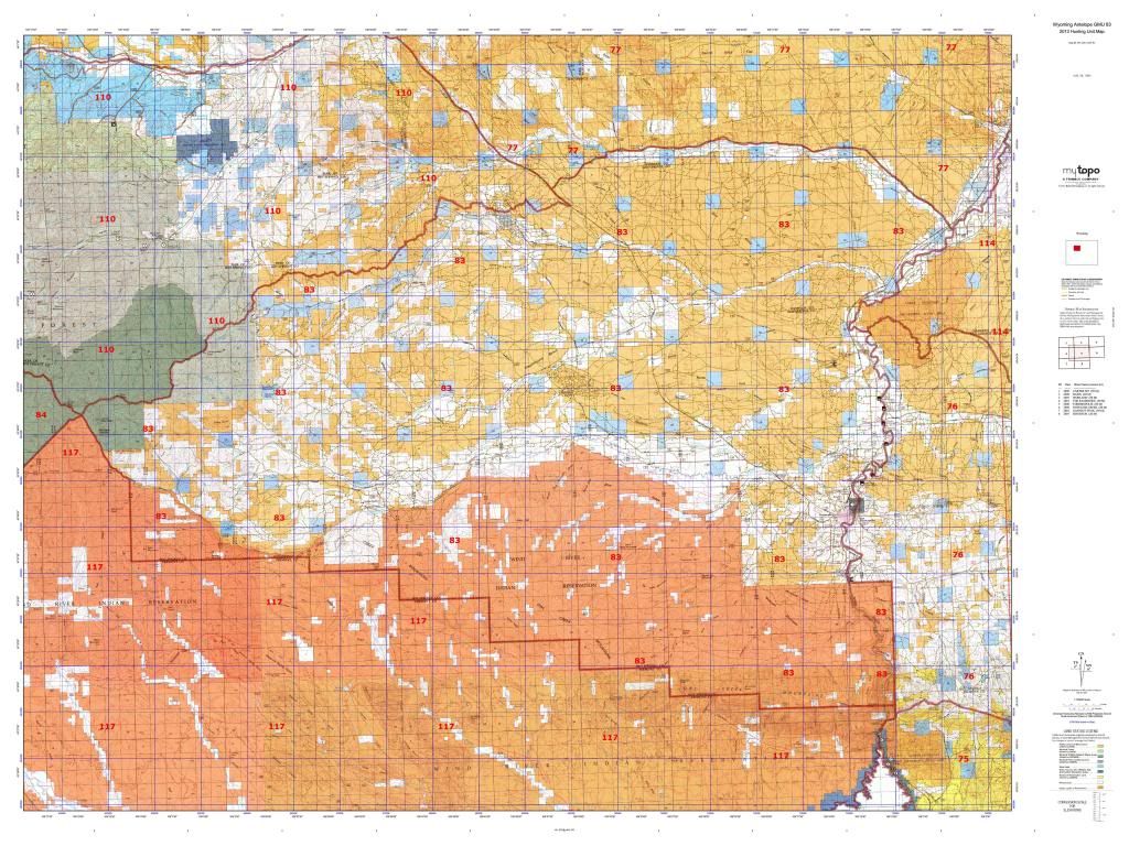
Thanks lib! Someone tried to tell me the county line or the line between 83 and 117 was the reservation boundary and that part could be hunted but it seemed pretty sketchy to me and I decided to look at other units. That map is off of mytopo and their maps are made off of blm maps, they just center the map on the unit you want the map of so it should be accurate.
libidilatimmy
Veteran member
Here's the description of the area. The last sentence includes any deeded land located within Hot Springs County and within the boundary of the reservation (the orange hatching in the hunt area), so that would mean your map is correct.
Area 83. Owl Creek. Beginning at the junction of Wyoming Highway 120 and
Wyoming Highway 431, easterly along Wyoming Highway 431 to the junction with
Wyoming Highway 432; easterly along said highway to the Big Horn River; southerly up
said river to the Wind River Reservation boundary, westerly, then northerly, then westerly
along said boundary to the divide between Owl Creek and the South Fork of the Wood River;
northeasterly along said divide to the divide between Cottonwood Creek and Gooseberry
Creek; northeasterly along said divide to the divide between Gooseberry Creek and Grass
Creek; easterly along said divide to Wyoming Highway 120, southeasterly along said
highway to the junction of Wyoming Highway 120 and Wyoming Highway 431; in addition,
all non-Indian fee title lands You are Hot Springs County within the exterior boundaries of
the Wind River Reservation are included.
Musket Man
Veteran member
Thanks for the clarification lib!!! I think when I was looking at that area I was actually looking into 120 deer, which is the southern part of 83 antelope and most of the non private land in it is on the reservation.
cycloneshooter
Member
Forgive my ignorance, i am trying to understand this completely. Any of the orange area (indian res) within unit 83, that is also inside Hot Springs County is also huntable public access? Is indian reservation permission still required?
libidilatimmy
Veteran member
No, the WRIR lands are not considered "public". In order to hunt within the boundaries of the reservation, a Non-Native American must be on deeded (private) land. The land that shows up as orange on the map is held in trust by the Feds for the tribes and tribal law applies.Forgive my ignorance, i am trying to understand this completely. Any of the orange area (indian res) within unit 83, that is also inside Hot Springs County is also huntable public access? Is indian reservation permission still required?
Topgun 30-06
Banned
ore hunter
Very Active Member
- Jul 25, 2014
- 699
- 114
cycloneshooter
Member
libidilatimmy, is there any way for a non native american to get permission on the WRIR (the orange area) or is it strictly off limits?
libidilatimmy
Veteran member
No, the tribal lands are strictly off limits to someone that's not enrolled with the tribes for hunting. I've even had encounters with tribal G&F while I was working where they threatened to give me a trespassing violation before even asking why I was on the reservation. Once I told them what I was doing and why, I was a land surveyor at the time, they're attitude completely changed. If a Non-Native American is found to be in violation of any tribal G&F law, no matter how frivolous in nature, the wardens are sure to write a myriad of tickets including trespassing.libidilatimmy, is there any way for a non native american to get permission on the WRIR (the orange area) or is it strictly off limits?
Fishing, now that is a completely different subject all together. It is legal for someone not enrolled with the tribes to be on this tribal ground, provided that you didn't cross deeded or allotted land without permission to get there, while fishing and having a tribal fishing permit in possession on the WRIR.