
Google Earth Scouting- What to look for?
- Thread starter GOSHENGRUNTER
- Start date
25contender
Veteran member
- Mar 20, 2013
- 1,638
- 90
It would be nice to hunt that type of area If it was on public land. Unfortunately Atleast where I hunt that is not a option. You are right got to do what others don't. Where we hunt the elk hold up away from the low lying areas. That is where most hunt in the unit I normally hunt.
Like road hunt in a 400+ tag, find something legal, unit?not to disagree with what has been said, but it is important to do what everyone else isn't doing from time to time.
")
Here's something else to look for. A lot of elevation gain leaving fields with some thick clumps of timber for them to hide in- with the ability to get up to feed in the small openings during the day (that you can't see except by helipcopter or GE). Never see any deer in there, elk keep them run off.
Find the benches that are on the top 1/3 of the ridge. Also the little thick patches on the hogbacks at that same upper 1/3. Even better if there is a low saddle close by going over to the next drainage.
Top of the ridge. Specifically here are the little finger ridges that come off of the main ridge. Elk will be bedded down on the little 10ft wide top of these things. Find the little benches where these ridges flatten out, and you are likely to find bedding areas.Great info guys thanks! Pardon my eastern-ness but what's a hogback?
Learned something. Always thought those were the big round topped hills that had the steep rock outcroppings off the back side. Those are the ones where you figure out most mountain animals are part mountain goat when the bail off the back side.Top of the ridge. Specifically here are the little finger ridges that come off of the main ridge. Elk will be bedded down on the little 10ft wide top of these things. Find the little benches where these ridges flatten out, and you are likely to find bedding areas.
Drhorsepower
Veteran member
Ive tried! too many dang trees. Elk are sneaky!I zoom in really really close and look for elk.
The best way to find elk is to buy a Rand McNally road map and look for a large town such as Jackson, WY. Drive to said town and look for upscale subdivisions and large tracts of land owned by very wealthy liberal people with anti-hunting views and very few wolves roaming their neighborhoods and you will find the elk.
http://www.jhnewsandguide.com/news/environmental/elk-sticking-closer-to-town/article_792f864f-2ff4-5ef7-8c88-76414bbb2863.html
http://www.jhnewsandguide.com/news/environmental/elk-sticking-closer-to-town/article_792f864f-2ff4-5ef7-8c88-76414bbb2863.html
BobcatJerry
Member
Check out the maps on Bing Maps. Go to the birdseye view. Where I have been hunting the photo they have has a lot more detail than GE. Birdseye doesn't have the features nor can you load point onto you GPS. I had a hunter tell me about a good spot where there was a watering trough. I knew someone had run poly pipe down from a huge spring, just didn't know why or where it ended up. Thought the guy was pulling my leg. Prior to the next year, I looked for it on GE, No luck, went to Bing and noticed this rectangular thing that was just too neat to be natural out in an opening, but still couldn't tell what it was. Went back to GE, and I couldn't see a thing. I went back to Bing and got the coordinates, and then made a waypoint on GE of the location and put it on my Garmin. Went hunting, and there it was, the watering trough. Both tools are great, just depends on when they update the maps and what resolution. Last year GE updated the map on my farm, you can see my tractor in the driveway, and the moss growing around the edge of my pond. Bing's map is still from 2009 and it doesn't even have the pond. Just depends on when they update. They do it more out east, so the tax man can get you ASAP for updates. Check it out, both are nice tools.
Dos Perros
Member
- Jul 1, 2015
- 128
- 0
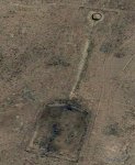
What in the world is this? On BLM land just below a low ridgeline/saddle? Appears to have fencing around it? I think I see tires, too.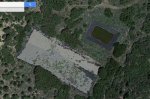
Dos Perros
Member
- Jul 1, 2015
- 128
- 0
Wow, quality really drops off with an upload...I'll try to host it somewhere if folks are interested.
ceby7
Active Member
I believe they're used to collect waterWhat in the world is this? On BLM land just below a low ridgeline/saddle? Appears to have fencing around it? I think I see tires, too.View attachment 13954
badgerbob
Active Member
This might be a heli-pond. They were put in to collect water for helicopters to dip their bucket in so the water can be dumped on fires. I have seen 2 but they didn't look exactly like this one, but close. They are usually on a ridgeline. Size is hard to determine from the photo. If it's a hundred feet, or so, it's a heli-pond. Much smaller and I would agree a guzzler.What in the world is this? On BLM land just below a low ridgeline/saddle? Appears to have fencing around it? I think I see tires, too.View attachment 13954
Dos Perros
Member
- Jul 1, 2015
- 128
- 0
That northeast portion that stores the water is 75' x 45'.This might be a heli-pond. They were put in to collect water for helicopters to dip their bucket in so the water can be dumped on fires. I have seen 2 but they didn't look exactly like this one, but close. They are usually on a ridgeline. Size is hard to determine from the photo. If it's a hundred feet, or so, it's a heli-pond. Much smaller and I would agree a guzzler.
While we are on this topic, can someone post a picture of what would be a good elk feeding area? I know that obviously on private land planted crop fields would be good feeding areas, but what would be a promising looking feeding area for elk hunting on public land without planted agriculture?