
CC in pic 7 it looks like a pump gun maybe a 270? Great pics. I really like the ones were there if 5-7 deer lined up. Those must have been the days.
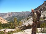
Backpack hunting D7
- Thread starter Red 1
- Start date
Muleys 24/7
Veteran member
Graylight and ColoradoCowboy, Nice pic's and thanks for shar'in. All the older hunters I know say they wish the hunting today,was the same as those days.
Colorado Cowboy
Super Moderator
D7 Hunting
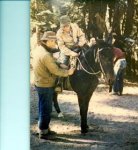
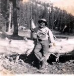
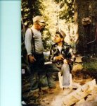
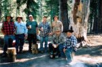
Found some more pictures The 2 colored ones were in 1953. I was 12 and my Dad was 35. The BW was in 1954 the next year. Compare to the last one from 2005. I was 64 and my dad was 87. His brother (my Uncle) is sitting next to him and is 84. All my cousins too.
The picture of the Rem pump was a 30-06. I still have it, but don't use it much.
I finally got my new printer/scanner setup and I love it. The scanner program is great!
Last edited:
 Thats really cool, some memories that you can enjoy forever. I plan on having memories like that with my boys, have already started.
Kevin Root
Very Active Member
Very nice Red 1. This was a great thread. Thanks for post it. Seeing and hearing about the adventures on this thread, past, present and for the future have been awesome.
Ya it got a little off topic but I have enjoyed it all the same.Very nice Red 1. This was a great thread. Thanks for post it. Seeing and hearing about the adventures on this thread, past, present and for the future have been awesome.
Colorado Cowboy
Super Moderator
Mabe...maybe not. I've backpacked/hunted all over the middle & eastern part of D7 and anyone with questions can sure ask.Ya it got a little off topic but I have enjoyed it all the same.
CC I have never done much more than day trips above timberline and I'm looking for any advice I can get on places that might hold some deer. I'm going to do a shake down run to Mt Givens and check out the basins that drain out to Mono hot springs, but kind of figure I need to go further in to the wilderness. If you could give me some advice on Piute Canyon or French Canyon drainages that might be worth looking at that would be great, or anywere else your advice is more than welcome.
Colorado Cowboy
Super Moderator
My experience with scouting in the summer is that it is really food & water dependent. Depending on the winter, the deer can be at very different altitudes. I've seen winters that were really hard & had lots of snow. The deer were really late and really never got very high from their winter grounds. I've seen really dry winters and the deer were never very far from water.
Walk the ridges that lead to the high basins and look for sign, check the game trails and for sure take your spotter and spend lots of time looking, especially early and late. On warm days, look for them in the shade. Above timberline there is usually lots of scrub and some grassy areas too. Cover & food! I've seem some good bucks laying in the warm sand when it's cold.
Best advice is look, look some more and take your time. If often ask mysef..."If I was a buck where would I be?" If I can I like to get above the areas I think hold deer and look down. Just like in a tree stand, they don't look up that much.
I am not familiar with those 2 area you mentioned. I'll check some of my maps I still have.
Graylight
Active Member
I have been up the Paiute side out of Bishop... It's a tough hike up to the border of D-7 but it is some good looking' country. You'll need to drop off to the West a ways to start finding animals. Don't go too late or you'll find out that they already shed and moved into transition zones awaiting the rut...
The drainage to the West of Desolation lake and Paiute both hold bucks but like I said... It's tough country and once you're at desolation lake, you'll find that it's a HUGE, FLAT slab of granite for a long ways! You gotta get to the West side and drop off into the drainages to find animals... The wife and I tried to day hunt it once... That was a little much as we left the trailhead at 1 AM and reached the West side by daybreak, hunted all morning to the NW and headed out that evening... 17.6 miles... Both of us were beat but she didn't complain... I think I whined the most about my knees, coming down the East side again lol... I'm getting old
The drainage to the West of Desolation lake and Paiute both hold bucks but like I said... It's tough country and once you're at desolation lake, you'll find that it's a HUGE, FLAT slab of granite for a long ways! You gotta get to the West side and drop off into the drainages to find animals... The wife and I tried to day hunt it once... That was a little much as we left the trailhead at 1 AM and reached the West side by daybreak, hunted all morning to the NW and headed out that evening... 17.6 miles... Both of us were beat but she didn't complain... I think I whined the most about my knees, coming down the East side again lol... I'm getting old
Last edited:
I thought as much I'm not sure that a hunt In that area is going to happen this year but mabe a pack trip next year. when I have the time off for it. Coming in from the east is not that feasible when I live in Paso.I have been up the Paiute side out of Bishop... It's a tough hike up to the border of D-7 but it is some good looking' country. You'll need to drop off to the West a ways to start finding animals. Don't go too late or you'll find out that they already shed and moved into transition zones awaiting the rut...
The drainage to the West of Desolation lake and Paiute both hold bucks but like I said... It's tough country and once you're at desolation lake, you'll find that it's a HUGE, FLAT slab of granite for a long ways! You gotta get to the West side and drop off into the drainages to find animals... The wife and I tried to day hunt it once... That was a little much as we left the trailhead at 1 AM and reached the West side by daybreak, hunted all morning to the NW and headed out that evening... 17.6 miles... Both of us were beat but she didn't complain... I think I whined the most about my knees, coming down the East side again lol... I'm getting old
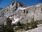
View attachment 3057View attachment 3058View attachment 3059
Colorado Cowboy
Super Moderator
If you get over to the Mammoth area, I can give you directions for a much shorter backpack hunt. Park at Devils Postpile parking lot and go to the Postpile, keep going south along the river and you'll find a foot/pack stock bridge across the river. After you cross the river the trail takes you to a junction where the Muir Trail takes off, take the left trail to King Creek and Beck Lakes. It is about 3 or 4 miles to the creek. I've camped there and hunted. Lots of deer, but nothing is even near timberline.
Cross the creek and the trail goes up and out of the canyon, a bit of a hike...all uphill. Near the top is a trail going to the right to Beck Lakes. There is some good hunting there, right at timberline and fishing too. Continue past what is called Summit Meadows (not much of a meadow anymore) on over the ridge. Down to what is called Upper Stairway Meadow. Good camping and water. Lots of deer and access to some great high country. Total distance from the trailhead is about 8 miles and the meadow is right at 9,000. If you decide to do any of this, get the Devils Post Pile Quadrange topo map.
A side bar. Summit Meadows is where then Gov Ronald Reagan rode into to hold a press conference to kill the Trans Sierra Highway.
Last edited:
Kevin Root
Very Active Member
Thanks for the write up on information Colorado Cowboy, Graylight and Red 1. Seeing all these pictures and stories has me wanting to explore D7 some more. I typically try for X12 or some different zones more up north when not getting drawn for X12 but D7 is calling me now this season and preseason too. The history and pioneer type spirit I've heard on the thread has me wanting to explore it some more. Thanks again!
Thanks I look forward to trying this area out. I'm going to check this out on my maps right now.If you get over to the Mammoth area, I can give you directions for a much shorter backpack hunt. Park at Devils Postpile parking lot and go to the Postpile, keep going south along the river and you'll find a foot/pack stock bridge across the river. After you cross the river the trail takes you to a junction where the Muir Trail takes off, take the left trail to King Creek and Beck Lakes. It is about 3 or 4 miles to the creek. I've camped there and hunted. Lots of deer, but nothing is even near timberline.
Cross the creek and the trail goes up and out of the canyon, a bit of a hike...all uphill. Near the top is a trail going to the right to Beck Lakes. There is some good hunting there, right at timberline and fishing too. Continue past what is called Summit Meadows (not much of a meadow anymore) on over the ridge. Down to what is called Upper Stairway Meadow. Good camping and water. Lots of deer and access to some great high country. Total distance from the trailhead is about 8 miles and the meadow is right at 9,000. If you decide to do any of this, get the Devils Post Pile Quadrange topo map.
A side bar. Summit Meadows is where then Gov Ronald Reagan rode into to hold a press conference to kill the Trans Sierra Highway.
Just a quick update I talked to the biologist he had a lot of info and was very friendly and willing to answer any Questions I had.
Drhorsepower
Veteran member
So what did he say?Just a quick update I talked to the biologist he had a lot of info and was very friendly and willing to answer any Questions I had.
Kevin Root
Very Active Member
I've gotten some awesome information from the wildlife biologists in the past for both fishing and for hunting. It helps for a good start at least narrowing down some places a bit at least. There is so much land to sift through and it helps a bit to narrow down some options. Best wishes to you Red 1 on your upcoming scouting trips you talked about and hunt ahead.Just a quick update I talked to the biologist he had a lot of info and was very friendly and willing to answer any Questions I had.
The biologist that I talked to deals with the southern part of D7. There are three herds that he monitors. The Wishon-Courtright area holds the highest density of deer. He suggested that I try and get as far away from high pressure areas, but didn't have any specific area he would suggest. When I told him about how many years I have been skunked up there, he was not surprised, and just said that the kill percentage is very low in D7 - which I already knew. He told me that if I wanted to see what a forest is supposed to be, that I should see inside the forested areas that Edison owns. He said if I had a friend that worked for Edison, or could get permission to hunt Edison lands that I might have better luck. Forestry practices in National Forest are either that they don't manage it at all, or they go in and plant a tree every foot, which does not create the optimum deer habitat. I am trying to sum up a lot of information, but he really knew his stuff. Don't take it from me, you should call yourself. I know I will be calling again.
NoMoreOldNo7
Member
Took my first archery buck in that part of D7 back in '96. Got him hanging on the wall as I type this. It used to hold quite a few good deer, but not so much lately and thats why I changed units a few years back. Good luck there this year and let us know how you do.