
By the way, sometime I've had luck with Google Maps "StreetView". Coverage is limited in public land areas but not entirely zero.
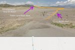
Here are two example spots. (Note: These aren't "secret hunting zones") The first is near Sedalia, along 285 where the road is lined on both sides with ranches and there is BLM/USFS land behind them. Many ranches can be crossed on access roads and signs on each one indicate the type of use allowed. The signs are very small but you can spot them on StreetView if you're careful. If you go to 38.195195, -105.941808 in Google Maps and go to StreetView you can see this:
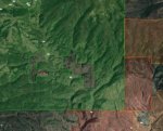
Another is a spot in GMU 15 near the Iridium SWA. The green here is USFS land and the red is the SWA. Note the access road goes right through a couple of ranches. Signs at the entry/exit points for that private land warn you about trespassing but access is allowed and the signs just say to stay on the road, no camping or hunting there, etc.
Here are two example spots. (Note: These aren't "secret hunting zones") The first is near Sedalia, along 285 where the road is lined on both sides with ranches and there is BLM/USFS land behind them. Many ranches can be crossed on access roads and signs on each one indicate the type of use allowed. The signs are very small but you can spot them on StreetView if you're careful. If you go to 38.195195, -105.941808 in Google Maps and go to StreetView you can see this:
Another is a spot in GMU 15 near the Iridium SWA. The green here is USFS land and the red is the SWA. Note the access road goes right through a couple of ranches. Signs at the entry/exit points for that private land warn you about trespassing but access is allowed and the signs just say to stay on the road, no camping or hunting there, etc.